Identifying spatial variability based on the combination of other images from the field is of utmost importance when generating a prescription, new soil fertility maps, or projecting yield through NDVI, among other examples.
The new extension of the recommender will allow users to generate one or several calculations by overlaying all the loaded layers in your field, resulting in a new image and SHP result files that can be imported into an application monitor.
Generating maps with the new extension is key to:
- Automating prescription generation.
- Enabling efficient management of inputs and applications.
- Establishing defined equations for agronomists in my operational environment.
- Standardizing task execution.
- Analyzing the evolution of inputs applied in the fields.
- Creating other useful information layers such as soil fertility, potential yield estimations, among others.
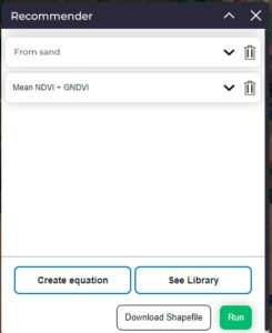
How to start generating equations?
1- Enable the “Recommender” extension within the extension marketplace.
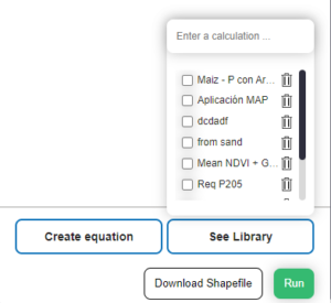
2- Upon entering the extension, you can create a new equation or access the library, where you will find a list of calculations saved by the user and/or Spaces.

View library
When opening the library, you will find equations saved and shared by the space administrator. If you access one or several saved calculations, they will be displayed as a list with the main component minimized. Upon entering, you can view the formula of the equation and the previously saved data.
How to create an equation?
1- Select “Create Equation”.
2- Fill in the name of your equation.
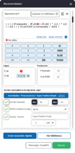
3- Start creating the formula for your equation. You can write it freely using mathematical functions (+, -, <, >=, etc.), logical functions (IF, ELSE, OR, AND, THEN), layers (their syntax will be given by the use of brackets “[P_20]”), or constants (their syntax will be given by the use of braces {Constant x}).
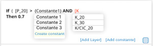
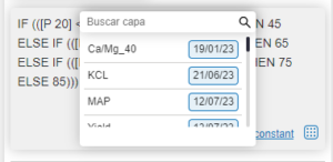
NOTE 1: Within the free text section, by clicking the “[Add layers]” and “{Add constant}” buttons, you can access a search engine with a list of all available [layers] and {constants}.

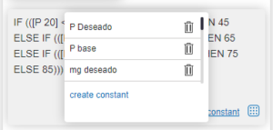
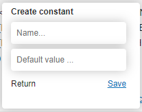
NOTE 2: If you have administrator permission, you can create your own constant by completing its name and numerical value.
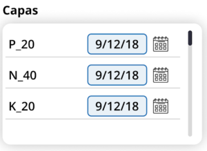
NOTE 3: When selecting a layer, the tool will bring the latest loaded layer by default. If you want to select an older layer, click on the calendar icon and choose the date of the desired layer.

4- Once the equation is defined, assign where the new result layer will be stored in the platform by clicking the “Assign Layer” button. For example: Activities – Prescriptions – Super Phosphorus Simple.
5- Finally, you will have the option to define details of the result for your new layer:
- Limit the results with a minimum and maximum value. Example: If the max is 45 and some values in the calculation are 50, the result for those values will be 45.

- Define the unit of the layer. For example: kg/ha. Associate it with an input and its cost. NOTE 6: If you have the corresponding permission, you can save your equation in the “library”.
- Your equation will be saved only if its syntax is correct.
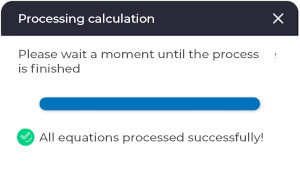
6- Once all the equations are loaded, selecting the “run” button will process all the calculations and create the layers with the details of your prescription.
If there are equations with errors, it will notify you which equations could not be executed due to syntax errors or missing data in a layer (The layer loaded in the equation does not exist for that field).

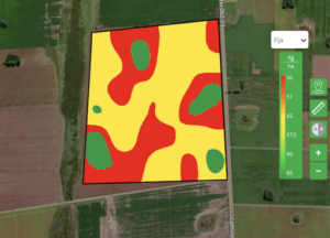
In the following example, we can see the already processed map with the recommendation for your prescription. In the green environments, an application of 85 kg/ha is recommended, while in the red environment, 50 kg/ha is recommended.
7- Download Shapefile
In addition to running the calculations and creating the layers, you can also download it in shapefile format, where it will calculate the average of each polygon/cell according to the selected map.
There, you will have a checkbox where, when activated, it will display the type of map to use in the download. Grid (30×30) or maps obtained from the list of maps in the field.